A short train and bus journey from Tokyo, for an easy hike around the stunning Nishizawa Ravine
There are some areas in particular which are always recommended for day trips from Tokyo. Nikko, Hakone or Kamakura can all be reached within a couple of hours from most parts of the metropolis. Whether it’s customs or culture, local culinary experiences, hot springs, cable cars to volcanic craters, ancient world heritage sites, beautiful scenery, these areas have so much to see and do that one day is never enough and it’s likely you’ll want to go back again (possibly again and again) to take in all the things you missed out on the first or second…or even third visit.
That’s why I’m recommending a simple, one-day trip from Tokyo to a natural beauty spot in Yamanashi Prefecture. If you don’t mind some mild physical exertion, then a short hike around Nishizawa Ravine could be exactly what you need. Located in Chichibu Tama-kai National Park, the ravine is considered to be one of Japan’s most picturesque and scenic spots, and it really is perfect for a quick, refreshing getaway combined with some light exercise.
Surprisingly for such an unspoilt location, the ravine is easily accessible from either Shinjuku or Tachikawa, Tokyo by taking the Kaiji No. 15 Special Express train (in direction of Kofu) to Yamanashi City. This takes 1 hour 25 minutes from Shinjuku and costs 1,580 yen one-way, and 1 hour 2 minutes, 1,020 yen from Tachikawa. From Yamanashi station, you can take the first 9:12 am ([Yamanashi Community] Nishizawa Ravine Line) bus for 900 yen up to the ravine’s entrance carpark, or a taxi. The bus takes approximately 60 minutes, but a taxi will take half that time. The return bus journey from the ravine to Yamanashi station will also give you a nice view of Mount Fuji on a clear day.
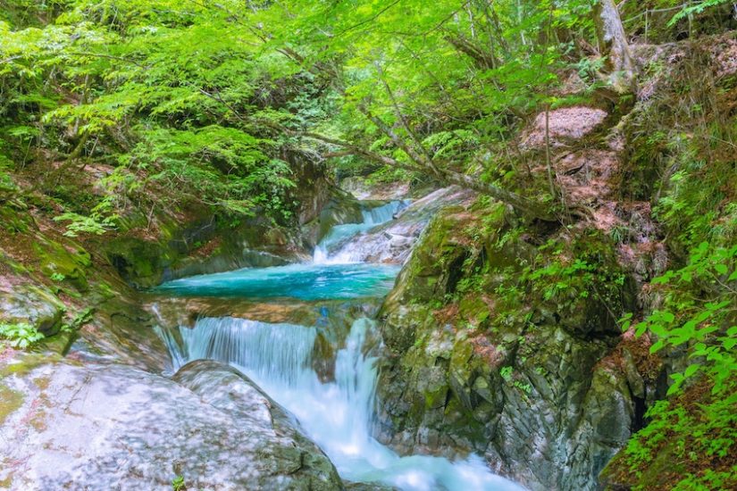
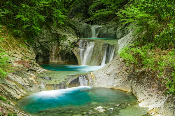
Nishizawa Ravine is a stunning, natural work of art which was formed over time through erosion of its granite rock by mountain streams and rivers. Today, the crystal-clear waters of the Fuefuki-gawa River run through the valley’s primaeval forest. These turn into rapids in places and tumble and cascade over rock ledges into pools and basins to form some gorgeous waterfalls.
There is a safe, well-maintained trail taking you along the sides of the ravine and connecting footbridges which give excellent views from various angles. Depending on how fast you walk and how long you tarry taking in the scenery or breathing in the fresh air at each viewpoint, the entire hike may take around 3 to 4 hours, but it’s possible to finish it quicker. It’s a good idea to wear sturdy walking shoes or boots, but this is not a tough hike by any sense of the word.
The valley is a natural “power spot” all year round. The most popular times to visit are in spring and autumn. The rhododendron flowers are an attraction for many in spring, but the colours of the forest leaves in autumn combined with the mystical mountain water of the falls are the biggest draw. There are several waterfalls located around the ravine, such as Mie no Taki Falls, Ryujin Falls, Koi-ito Falls and Sada-izumi Falls. The highlight of the walk, however, is surely the “Five Steps and Seven Pools” Falls — directly translated from “Nanatsugama Godan no Taki” (七ツ釜五段の滝).
It should come as no surprise that these are designated one of Japan’s 100 top waterfalls. In addition, the valley walk is listed as one of Japan’s 100 top “forest-bathing” experiences, with the river and its tributaries being named in the Heisei era 100 top waterways and river sources.
Note 1: Depending on how much snow has fallen the Nishizawa Ravine may be closed to walkers between the months of December to April.
Note 2: The Japanese name Nishizawa Keikoku (西沢渓谷) has been variably translated into English as Nishizawa Gorge, Valley, Ravine or Canyon. Don’t be confused as these are all exactly the same place. The word “keikoku”(渓谷)is defined as a “small, deep valley with steep sides” and there is usually a river running through it. In this article, I’ve used the word “ravine” due to the narrowness of the valley, and because that is the English name used on an official information map at the entrance to the valley.